


Editor’s note: This article was published eight years ago on Meridian Magazine. We publish it again today and also announce that October 12-24, 2008, we will be returning to the Arabian Peninsula to follow Lehi’s Trail again. And we invite you to join us (limited seats available, of course). We will be going with Warren Aston of Australia on this most exciting adventure. This tour is not for the faint of heart. Watch for more information on Meridian and/or e-mail us here: [email protected] We’ll send you initial details and pricing.
“We were exceedingly rejoiced when we came to the seashore; and we called the place Bountiful because of its much fruit” (1 Nephi 17:6)
Lehi’s journey as described in the Book of Mormon is a strange and epic tale. He and his family wade through a barren wilderness for eight years, facing every sort of deprivation, to arrive at a jewel of a green refuge called Bountiful. Here is fruit in abundance, a tropical ocean, and a velvety jungle on mountain slopes where hardwood trees tower, suitable for building a ship.
Critics in Joseph Smith’s day simply hooted at the story. According to Hugh Nibley, “The best guide to Arabia at the time … imagined forests and lakes in the center of the peninsula, while insisting that the whole coastline was ‘a rocky wall…as dismal and barren as can be: not a blade of grass or a green thing’ to be found.” This certainly didn’t fit the Book of Mormon story.
Yet even later when Europeans came to probe the Arabian Peninsula and understand its geography, the story still seemed fantastic to the unbelieving critic. Now they agree that Arabia is a desert, about as forsaken and unrelenting as any place on earth, but how and where in all this desolation could there be a seacoast forest that Nephi once called Bountiful.

The question has always been intriguing. For his early 1950’s series on the Book of Mormon in the Improvement Era, Hugh Nibley pored through the works of early explorers and found the writings of Bertram Thomas, who shed some light on the puzzle. Captain Thomas in 1928 had traveled through the arid wastes of the southeastern corner of Arabia and then been delighted and amazed to descend from an arid steppe to finally pass through “wooded valleys,” “sylvan scenes,” and lush forests to the sea.
Yet it took two hardy Australian Saints, Warren and Michaela Aston, to actually pack their bags, fly to Oman and begin tramping up and down the coastline looking for Nephi’s Bountiful. As expected from the various reports over the years since Thomas’s, Arabia does have a tiny stretch of verdant coastline, made green by the monsoons that pelt this corner of the land and nowhere else. This forest is Arabia’s surprise, an anomaly in a land of sand and mountains like the moon.
But the Astons wanted more. They wanted to test the land against Nephi’s description to see if any specific location matched. Nephi gave us many specific clues about his Bountiful. Clearly, it was coastal, accessible from the interior along a reasonable route. What’s more, it was fertile, a place of “much fruit” and honey where the group could grow crops to maintain themselves as they built a ship.
For a place to qualify as Bountiful, it had to have timber in enough types and sizes to permit ship building and a mountain prominent enough to be called “the mount,” close enough that Nephi could retreat there and “pray oft.”
Bountiful also had to have ore from which metal could be smelted, a source to make fire, and probably a cliff by the sea where Laman and Lemuel could have made good their promise to throw Nephi into the deep.
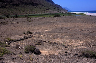
With this comprehensive set of clues, the Astons combed the coast and seriously considered six areas as candidates for Bountiful. Only one of the six was a fit-a tiny beach only a kilometer and a half wide called Wadi Sayq, nearly on the border between Oman and Yemen. On either side of the beach are 2,500-foot cliffs that drop straight into the sea, making access impossible along the shore, but the wadi (like a dry river bed) cuts its way 15 miles through a steep canyon into the interior. This is the beach’s only entrance, difficult enough to travel that even though the beach basks glorious and green in tropical sunlight Wadi Sayq is remote and forgotten. To this day it is uninhabited, except by the occasional cow who finds its way there to graze.

Was this the place where Nephi built the ship? The Astons were compelled enough by the match between Wadi Sayq and Nephi’s description of Bountiful that they published a paper detailing their research for FARMS, the Foundation for Ancient & Mormon Studies (“And We Called the Place Bountiful: The End of Lehi’s Arabian Journey”).
We first came upon the Aston’s paper while preparing to photograph and write our book Light from the Dust: A Photographic Exploration into the Ancient World of the Book of Mormon. This was the third in a trilogy of photographic books we had created, and by far the most difficult. Our purpose in the books had been to make vivid and tangible the sacred events of the past by telling them scene by scene with photographs of the actual places.
For the first book, Witness of the Light, we had photographed those places significant in the restoration and in the life of Joseph Smith. The places were documented with land records, property deeds, structures, homes, streets, and fields all directly tied to Joseph and his contemporaries.
Photographing the land that Jesus knew for Source of the Light was more of a challenge, but with Jewish and Christian names, and the almost timeless land of Israel, this task could be reasonably accomplished. But how do you photograph the Book of Mormon lands? Where do you go to shoot Zarahemla when no road signs have yet been found saying “Zarahemla-City Limits”? How do you follow the path of Lehi from Jerusalem to Bountiful when the literal sands have blown over the trail for nearly twenty-six centuries? Where did Nephi build that ship?
We were grateful for the Astons’ research on that last question, and so, grabbing our camera, 350 rolls of film, sleeping bags, bug spray, and the Aston’s paper that included a few hand-drawn maps, we prepared ourselves to take off for Oman in May 1992.
On the trail of a mystery, there are always obstacles, and we ran into our first one even before we left Salt Lake City. Though we tried diligently to obtain visas for Oman, we failed. Oman is an Arabian sultanate, immaculate, rich, protected, hidden away like one of Ali Baba’s treasures. Until recently, they didn’t allow tourists at all. The year before we applied for our visas, they had only admitted 8,000 tourists, 6,000 of them Arab.
Asking travel agents about Oman, we got only blank stares. Nobody had been there. Nobody knew anybody who had. The best advice we got was to fly to Cairo and to try to get our visas there.
At the American Embassy in Cairo, the official said we’d never get a visa for Oman. Yet, driving to the Omani embassy through the jungle and heat of Cairo traffic with horns honking and twelve cars vying for six lanes of traffic, we felt what we normally wouldn’t have felt in the din: the Spirit whispered peace to us, a quiet assurance that pierced through the noise.
At the Omani embassy we asked for visas, and the man behind the desk looked at us indifferently, saying an English sentence he had used many times before: “It is impossible.” Still the Spirit had whispered to us, and to this we clung, sitting down on the office couch as if we simply didn’t understand the word impossible. Finally, not certain how to get rid of us, he gave us visa applications, and a week later we were on our way.
We are always extremely specific in our prayers, asking the Lord to touch every detail of our journey. Now, flying to a country nobody could tell us about, we prayed fervently that He would provide a good map for us, as good maps are extremely difficult to obtain in Arab countries.
Renting our jeep in Salalah, we looked over the tourist maps available. They didn’t offer the detail we needed to find a remote wadi well off the paved road. We asked the man at the car rental agency if he didn’t have anything better. He looked to the right and to the left and then said to us in hushed tones, “I can give you this map, but it is a top secret military map. Be careful.” We studied the map with gratitude. It was in English, was an extremely detailed topographical map, and covered only the area we wanted to travel, kilometer by kilometer.

Eighty miles south of Salalah, in a land nearly unrelieved by vegetation or people, the paved road began to wind tortuously around the dry, steep gorge that is Wadi Sayq. The wadi drops off the western plateau at about 4,000 feet and winds sixteen miles down a narrow path through limestone canyons to shore. From our vantage, at the beginning of the wadi’s descent, it was not evident that in a few miles the canyon would be lined with jungle, that the unrelenting brown would give way almost instantly, at the turn of a corner, to emerald forests.

If this was the way Nephi and his family came, it would have been like this. They would have had no indication, as they began to wind through a canyon, that the sea was so close, that within miles the thirsty, folded land would be blanketed in green only two miles from shore.
We saw a type here. We are told to “endure to the end,” to bear with patience our tribulations, yet the end does not always announce itself. Sometimes when we feel we can be brave no longer, all that is required of us is just a little more.

Unable to travel the wadi to the shore, we found an unmarked dirt road that we hoped would lead to Rakhqut, a tiny, seaside village about six miles along the shore from Wadi Sayq. Our calculations were correct, and we arrived after dark to a village shut down for the dry season, its inhabitants retreated to the mountains. It stood quiet and ghostly on the shore of the sea, a silent mirage.
We stopped the one truck we saw and with gestures and a few words asked, “How do we get to Wadi Sayq?” They answered that the only way to go there was “by ship,” and we understood that in the morning someone would help us.
In the evening darkness, we drove out of the nearby deserted village and parked by the beach, trying to find a place to rest. The stars shone brightly over the Arabian Sea, the northeastern curve of the Indian Ocean. We walked to shore, trying to decide which stretch of sand to sleep on, when suddenly a set of headlights and a horn pierced the night.
We went toward the lights with some anxiety. Had we broken a law? Was this the military or the police? In true Arabian hospitality, it was a few remaining villagers come to greet us with cold drinks and an offer to take us to Wadi Sayq the next morning in a fishing boat.
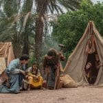
Our navigator was to be a scrawny fourteen-year-old boy who spoke only Arabic. We showed him our photocopied pictures of Wadi Sayq from the Astons’ paper, drew maps in the sand, pointed in the air, and finally, somehow, came to an agreement. He hadn’t been to the wadi, but he recognized it.
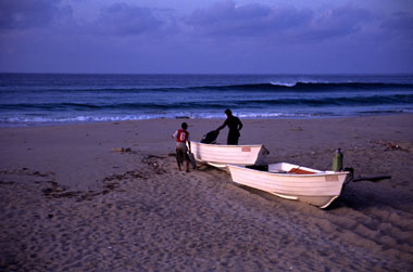
Placing $6,000 of camera equipment in the front of an 18-foot fishing boat was a little disquieting the next morning. The six- and seven-foot waves crashing onto the beach looked as if they would easily swallow a Pentax, a Nikon, and us — and no life jackets were available. But this boy knew the ocean and he watched the waves and at a signal pushed us quickly into the sea. Not one drop touched us or the equipment. Within minutes, at full throttle, we arrived at one of the most beautiful locations in the million square miles of Arabia. The boy haltingly uttered his first English sentence, “This is Wadi Sayq.”

We landed at the far west end of the beach and, wading through the night’s tidewater pool, we brought all our gear to a higher area by a large rock and began drawing symbols and pictures in the sand to encourage the boy to come back the next day to pick us up. Three o’clock was the appointed hour; we would have 32 hours to photograph this place.
Wadi Sayq is one of two “rivers” in Arabia that flow near the shore with water all year round. Trees abound with “much fruit” available in the form of date-palms-fruit to the Bedouin way of thinking. Dolphins playfully frolic in the waters near the beach wild flamingos wade in the fresh water, searching for food. We began quickly scouting for pictures in the early morning light.

It was, as the Astons suggested, a place that perfectly matched Nephi’s description. A free-standing mountain occupied the southwest of the beach. Towering tamarind and sycamore trees suitable for shipbuilding grew up in the wadi a few hundred yards away from shore. Here was a freshwater source, sardine in the sea for eating, land and water to grow crops. We had seen jasper deposits at the top of the wadi, suitable for striking together to make fire. These were a startling combination of characteristics in Arabia.
Monsoons water the area from June through September, creating a knot of jungle and undergrowth in the wadi and seaward slopes, but since we were there in the driest month of the year, May, we soon learned we had come with disadvantages and an advantage. The land was not as beautiful for photography, but the vegetation had burned back, exposing the wadi’s secrets.

The Astons had written that they had found archaeological remains in Wadi Sayq, signs of former human habitation. They reported that on the east side of the wadi stood a mound some twelve feet high and forty-five feet in diameter, now covered with wind-blown sand and vegetation. Radiating from this mound, they noted, were double lines of stones. One of them stretched about ninety feet toward the beach. A second double line of stones, some 400 feet long, curved back toward the freshwater of the wadi.
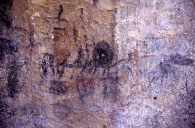
They also reported a rock face, not far from the mound that contained several groups of graffiti. Though some of the graffiti looked relatively recent, sketched on the rock was what appeared to be a much older set of graffiti, its red pigment faded with time. Painted in that faded red on the rock was a ship.
We began our exploration of the wadi on the opposite side from the mounds, asking the Lord to open our eyes to see what was there. As we walked, we started to see double lines of stones everywhere. One line over 600 feet long stretched perpendicular from the beach, back into the trees. Another at right angles to it ran across the valley. The more we walked, the more we saw. One sixty-foot line of double stones ended at a twenty-four-foot square collapsed area.
On we walked, exploring the wadi, double-checking the Astons’ paper to see if they had mentioned any of this. They hadn’t. We wondered if their silence indicated that they had come in the wet season and that vegetation had obscured the view.
The further we explored, the more stunned we were. Who had built these double lines, and for what purpose? Further down the wadi, we saw a foundation. Not far away we began to see several three-feet high stone structures shaped like an omega. A little father, we saw the remains of an ancient well. At every turn, we documented what we saw, taking hundreds of photographs in just a few hours.
We started to do more concrete thinking about Nephi and his family than we ever had before, lifting them out of the vague nowhere land of our imagination to begin to wonder how practically they had accomplished their mission at a place called Bountiful. Just before they had come to Bountiful, they had traveled through the wilderness of their much affliction, probably skirting the world’s most terrible wilderness — the Empty Quarter. This is a place so miserable that its first recorded crossing was in 1928. Surely, upon their arrival at Bountiful, then, they had been out of food and needed to grow crops to store to take with them on their long ocean voyage. They had probably been there for more than one season.

Throughout the day, we explored both sides of the wadi, sloshing back and froth across it, photographing the mound, the graffiti, and more, but if an Arabian Sea beach home was a refuge to Nephi, it wasn’t to us. The 110-degree heat was enervating, and we guzzled our bottled water shamelessly, not wanting to trust the fresh water at the site. By night we marveled that anyone could have built a ship in a place so beautiful but uncomfortable.
Sleeping was nearly impossible with the heat, the hungry mosquitoes, and noisy sand crabs. After a short while, our skin began to twitch from the insect poison it carried. We finally fell into a fitful sleep, amazed at what we’d seen and hoping the boy would remember to come get us the next day.
By morning, we were quickly running out of water, so having photographed extensively and hiked as far as strength would allow, we decided to rest in the shade of the rock face with the ancient graffiti, read 1 Nephi and pray. Somewhere in the middle of chapter seven or eight, we began to feel little pains on our legs and pulled up our pant legs to see we were covered with ticks — ticks already red with our blood. (Scot ended up with 137 bites that took more than four months to heal.)

From our vantage in the shade at a high point on the beach, we strained our eyes toward the southwest side, watching for the boy to return. Suddenly we saw something. There before us, in a path we had blindly walked over perhaps five or six times, was an oval rock pattern outline on the beach in the exact shape of a ship. We walked around it, observing it closely. It measured 130 feet long by 65 feet wide. At each end and in the middle of the pattern was a large buildup of rocks.
Could these have been the supports for the scaffolding of a ship? Curiously, here, in this oval shape, the vegetation grew more densely. We knew that archaeologists have often observed that where wood has deteriorated, vegetation grows. And if people built a ship and launched it, they would certainly not stop to tear down their scaffolding but leave it, as is, to decay into the earth.

Finally, we noted piles of rocks leading in succession to the high-water tide line of the ocean, perhaps used as supports for a launching ramp.

Not far from here, we noted a large, concave, half-moon-shaped rock with an air shaft that ran completely underneath. Observing the traces of carbon built up on the rock face, we mused that this might be a candidate for a foundry. The rock, the mound, and the oval shape of a ship were all proximate to each other. We wondered if the double line of rocks from the fresh water to the mound was to bring water to run some kind of waterworks, if the mound might have once been some kind of pulley system used to build a ship.
We also wondered if the double line of rocks from the fresh water to the mound was used in any way to transport the lumber from the large trees that grew a little further up the wadi.

For us however, the time at Wadi Sayq had ended. In this forgotten place, we had discovered what had not been seen before. As we hopped into the little boat, this time with four other Arab boys, and headed eastward on the ocean to the village, we would have been content to ponder what we had seen.
Instead, we had not been traveling five minutes when the boys cut the motor way back. We turned around to see their faces white with fear. We had noticed a large, dark swell of water to the front of the boat. “What’s wrong?” we asked.
“Nimrani!” they cried back.
“What’s a nimrani,” we asked.
“Very big fish. Eats people.”
“How big?”
“Bigger than the boat,” was their reply.
We later learned that our little boat had been floating on top of a whale shark, which can be as large as 65 feet long and weigh 70,000 to 80,000 pounds, but they are not hostile, which knowledge would have been comforting at the time.
Moments later, large five- and ten-pound fish were jumping headlong out of the water and over the full length of our boat. Fish after fish, seemingly defying gravity, sprang over our boat. The boys handed us our empty two-liter water bottles and motioned for us to protect ourselves by “batting” them away from us.
So what do we conclude from our trip to Wadi Sayq? We do not know who made that mound, those double lines of stones. We do not know who left the shape of a large ship on the beach there with piles of rocks that lead to the ocean. We do not yet know conclusively in what time period these things were built. Nor, at this point, without further study, can we be sure exactly what the original purpose was for the scanty remains left behind. Since our trip, FARMS sent a team of scholars to observe the area. A few others have returned as well. Much is left to be discovered here.

What is clear is that Lehi’s desert journey, ending in a lush refuge called Bountiful where his family built a ship, is perfectly plausible. A place that perfectly meets that description exists. There on the beach remains the shape of a ship. It is not unlikely that Wadi Sayq is the very place where Lehi came. Whether it is or not, someone found the eastern coast of Arabia a fine place for shipbuilding, complete with ample trees.
How could Joseph Smith have known any of this when he translated the Book of Mormon in 1829? He couldn’t have. That Wadi Sayq exists is, as Hugh Nibley would say, another “bulls-eye” for the Book of Mormon.